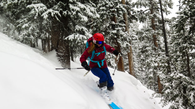
Between Christmas, Thanksgiving, illness, house projects, lack of snow, and a laundry list of other dumb excuses, we hadn’t managed to get on snow until MLK weekend. We fired up Xterrible at 5:36 in the AM and made good time on the highway until we got to Golden on I-70 at which time traffic ground to a crawl. Fast forward three excruciating hours to 8:30 AM, and we found ourselves standing in a humongous line in the A-Basin base lodge hoping to fill up on Huevos Rancheros and bad coffee. Regarding first chair: all hope was long since abandoned.
It was a weak storm anyway, grapes were sour, etc… But before we had unloaded at the top of the BMX we had hatched a plot: drive up the night ahead of the storm, follow the snowiest road as far as it would go, unroll the sleeping bags in the back of Xterrible and crash in place. While all the front-range powder-chasers toil on I-70, we’d be waking up at our leisure, a short drive from the goods.
Line the bed with a heavy wool blanket. Mobile homes are notoriously difficult to heat because there is cold air beneath the floor. Xterrible is no different in this regard.
On top of the blanket: two-man 20-degree synthetic bag for extra cushiness and insulation from the cold.
Inside the 2-man bag: the Therm-A-Rests. Ideally, use two of the insulated blow-up versions. Neither the closed-cell foam nor the uninsulated versions will be as warm.
On top of it all, 10 or 20-degree down bag, or similar.
Crack a window to let all your breath out, otherwise, the inside of the car will turn into a little ice cave and then it will rain on you as you drive away and the car warms up.
The temps were from mid-twenties down to maybe 15 and we were too warm and had to unzip everything in the middle of the night. We could have been comfortable in much colder weather. We’ll be doing this again!
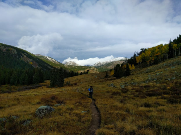
This is easily one of my favorite hikes of the year, both because it satisfies the ‘well-rounded adventure’ requirement and because of the amazing variety of terrain. It’s in the Indian Peaks Wilderness, which is accessed via 4th of July Road. Passing through the town of Eldora and riding up the 4th of July road is cool enough, and if you have a stout 4×4 you can mercifully knock a mile or so off of the 15 mile total. Depending on the weather, this may also prevent you from having to walk an appreciable distance through a giant puddle. Either way, you add a short but mildly technical off-road jaunt to your otherwise human-powered day. As icing on the cake, the final stretch deters most motorists, leaving the limited parking at the end of the road a pretty good bet.
Our day started off inauspiciously: drizzly and cold. Once the rain had more or less quit, we hit the trail. We were slightly disappointed to find ourselves in the company of large party whose crime was nothing more than excitedly talking amongst themselves, but it sort of tainted our wilderness experience for the first few miles: alas the trails must be shared! Eventually, they took a different fork than us and we seemingly had the wilderness to ourselves. Free at last!
Eventually, the rain totally stopped. It remained brisk, but the only further precipitation was the light, frozen variety. As we got further into the wilderness we passed bright aspens, plunged through dark evergreen forests, crossed expansive alpine meadows, stopped at more than one pristine lake, and finally climbed into the alpine tundra. You spend substantial time above treeline and get plentiful views of the mountains to the west, Winter Park to the south, and all of the terrain you’ve just crossed back to the east.
Once you’ve traversed the tundra and get within sight of Rollins Pass, it’s just about all downhill. Before long you’re traipsing back through the forest on the way back to the trailhead.
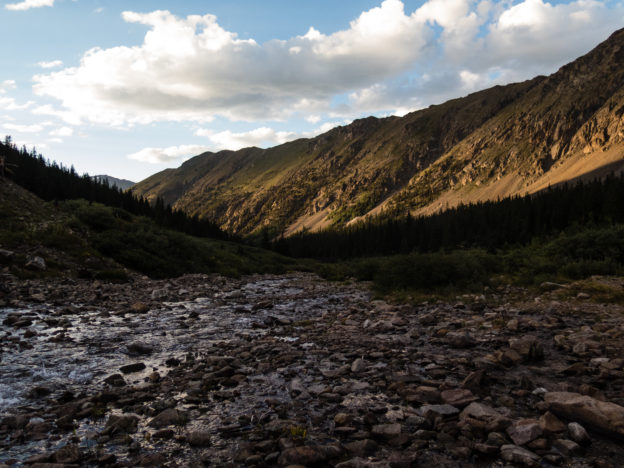
We chose a doubleheader for our first 14ers of the year and it did not disappoint! The hike itself is pretty straightforward: am obvious trail departs from the road and leads you via the path of least resistance up Grays and then Torreys. An optional knife-edge trail descends from the summit of Torreys, which we omitted, but could be used as a nice way to vary the scenery on the return trip. It doesn’t really change the mileage but ads some exposure. Both summits offer glorious views of the Summit County mountains. But the factor that really takes the cake for me is the stunning alpine valley from whence you begin. The best way (IMHO) to tick off these peaks is to drive up Stevens Gulch Road the day before until you get to the end or until you’d rather not punish your vehicle any further. The road peters out nearby an extensive alpine meadow sprinkled with mining remains and ample opportunities for car camping. Get an early start, find a nice camp spot and take in some world-class views while you acclimate. Waking up at the trailhead really takes the edge off of a 14er and the ambiance is second to none!
It occurred to us the other day, that for some reason we haven’t been backpacking once yet in Colorado! Clearly this was unacceptable, so Kelly picked out a nice warm-up outing so we could get our backpacking legs under us for the season. We booked a spot at Ouzel Lake, which has an upper and lower site. The lower spots were filled so we settled for the upper sites. The upper site is a tad farther from the trail-head, though in either case the whole walk would have been roughly 10 miles round trip. Would have been…
We’ll return to that thought in a bit. Before all of that, we travelled over a gently climbing and well maintained trail that hugs the St. Vrain and then the Ouzel Creek, through sparse pine forests, over several aesthetically appealing timber bridges, past raging cascades and eventually onto a thinly treed ridge offering 360 degrees of views, at least 270 degrees of which are spectacular.
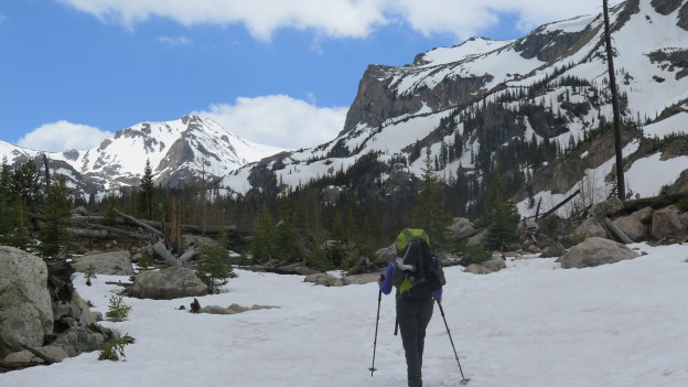
…And as you can see above, the trail was ultimately smothered by an expansive blanket of snow. The well traveled bits and the sun baked parts were plenty supportable and we hardly needed our spikes. In fact, all was well until we lost the trail somewhere after the lower camp area. No worry; we’d just use Backcountry Navigator and the USGS tiles I just downloaded for the region that morning. We navigated back toward the trail and followed it up hill and into the woods through increasingly deep snow and steep terrain until we found ourselves standing atop a snow-bridge under which the Ouzel Creek roared savagely in the spring melt.
After Kelly briefly dipped a foot in the water we agreed to follow the trail as closely as we could without crossing any buried water. We bushwhacked further up a convoluted pine forest that would have made for an absolute playground of midwinter tree-skiing: constant pillowy undulations, and perfectly spaced trees. We navigated off trail through cliffbands and around snowy canyons until we were approximately to the location marked on the map as the upper campsite. After a solid hour of travel, we had covered only one mile. Bushwhacking in shin deep snow is no joke!
A second, third and maybe fourth look at the map revealed that we should have been standing in the creek. Indeed, we were standing on a small ridge running east-west. The creek emerged from a cliffside roughly to our north, and traversed under us to the south. We pondered this paradox briefly before concluding that we were standing on a massive snow drift (25 feet deep at least!?!?!) with running water below.
We realized that the campsites were essentially no more find-able than the trail, so we backtracked down toward the lower site. The lower site was in a similar state of affairs. No gargantuan snow drifts, but all low lying, flat terrain was buried in who knows how much snow. At least it was flat. Somewhat indifferent with defeat, we settled on the first level spot, threw down our packs and made camp.
Turns out, the spot we arbitrarily settled on could hardly have been better. Water was close at hand, and the views in either direction were great. We feasted, set up some time lapses, shot photos, strolled about and crawled into bed as soon as it was acceptably late. A nocturnal bathroom break yielded absolutely still air, a brilliant half moon, and surprisingly good visibility – no headlamps needed really, even though it was the middle of the night.
It must have been below freezing for most of the night, because the snow firmed up as soon as the sun set. Around 3 or 4 in the morning my 45 degree back became a little bit inadequate so I pulled on a down jacket snoozed happily until the sun woke us both in the morning.
When we crawled out of bed, our boots, socks and packs were covered in a light frost, which evaporated almost as soon as the sun hit them. The hike out was fast and cool in the morning air. In a couple of hours, backpacking number one was in the books and we were on our way to après-hike Mexican food.