For the holiday weekend, Kelly and I trekked out to Steamboat Springs, CO for some multi-sport action. Since moving to CO, this has been one of our most far flung excursions (the only contender being a Valentines weekend jaunt out to Aspen). The weekend, on the whole, epitomized the 1Water1Coffee1Beer ethos.
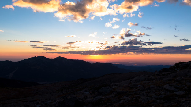
In our customary dirtbag fashion, we established our base camp at a Forest Service campground by the name of Meadows atop Rabbit Ears Pass just east of Steamboat. We had hardly put up the tent, the awning and started a fire when it began to storm. Distant yet ominous thunder, brooding clouds and light drizzle presaged the theme of the weekend: escaping summer squalls by the skin of our teeth! By some miracle, the storm rolled through quickly without dousing the fire…

Dinner Time!

Kelly warms up pork tacos on the new Coleman Triton stove.

Adventure mobile deluxe, ready for action!
We planned a jam-packed weekend of adventure, stretching each of our four short days to their limits. Our first full day was spent riding the Beall Ridge loop, just outside of Steamboat and is prominently featured in the video above. We slogged our way up through a lush late spring forest, caught our breath on a pleasant and scenic traverse and literally raced down the home stretch, through wild flowers and around hairpin turns just hardly keeping ahead of the looming weather. We actually were caught in the rain just a few minutes before completing the ride, though this had the happy advantage of subbing in for a post-MTB shower.
Day two was a fine exemplar of the adage “No battle plan survives contact with the enemy”. The general idea was to kayak a quiet section of the Yampa River. We’d stash a bike in the woods where we intended to quit for the day, then drive upstream to our put-in. From there we’d paddle back to the bike, Kelly would stand guard over the boats, while I’d retrieve the car by bike. We picked up a couple of cheap green rain ponchos at the local mountain shop, and scoped out a bike friendly route for the car shuttle the prior evening. On the morning of the paddle, we successfully stashed the bike in a bush, chained it to a tree and camouflaged it the ponchos and some nearby vegetative debris. You really had to be a five feet away and looking right at it to discover it. Confident in our subterfuge, we rolled off for the launch point, unloaded the boats, gathered everything we needed for successful boating (beer, sunscreen, snacks…oh and definitely life jackets) and shuttling (car keys, bike lock keys, bike shoes, bike gloves, bike helmet…pretty much everything but a patch kit because who needs a patch kit when you’re doing an eight mile road ride on a mountain bike with tubular tires that was recently tuned up?) and drifted off down river.
Those of you practiced in the subtle arts of foreshadowing, may have just noticed some. As expected the Yampa was pretty placid. In fact, we started going out of our way looking for the more exciting lines down river, just for fun. And by ‘more exciting’ I mean little gurgles that would hardly pass for whitewater of any class at all. The time lapse footage from the video actually shows us making our way through a few of these pitiful hits and honestly one frame per second is too slow to actually catch any action. Still, picking out little B-lines of swift-ish, choppy water in the afternoon sun was damn good fun.
About 2/3rds of the way down the segment we beached for snacks. Discovering the GoPros to be dead and eyeing a tasty looking line around the next bend, we stowed everything that could be stowed in the drybags and in the holds. Behind a little island in the river we could see some fast moving water that would require some hard paddling and careful maneuvering around a down tree. We decided to have a go of it and I went first. I always find that my boat handles better when I’ve gathered some decent momentum, so I charged into the bend at full tilt. The events that happened next panned out so quickly that I really didn’t even time to curse. From our vantage point on the opposite shore, the muddy island in the middle of the river had obscured from us much of the line. Once I cleared the island I was met with the realization that this massive oak tree was no mere feature to be negotiated: it was an impassable obstacle which would suffer no negotiation! Not sure she could even hear me, I made an about face and warned Kelly to abort before the two of us were both caught in the same trap.
Fortunately she was able to veer off in plenty of time. I, on the other hand, found myself doing an in-depth study of the futility of doing a one-eighty in 14 foot sea-kayak in swift water with only about 15 yards to work with. In short order, I found myself pinned broadsides, against a hump of grassy muck, nearly perpendicular to the flow.
Lest we all become mired in speculation over all of these shores, islands, and humps, I’ve prepared a detailed diagram, seen below.

Seeing that Kelly safely avoided a similar fate, I took a few breaths and paused to consider my situation. I had already expended considerable effort trying to turn upstream and escape, to no avail. Several more such attempts would no doubt exhaust me, and lead to some sort of mishap. I thought that maybe the smartest thing would be to paddle forward, around the hump and away from the shore in hopes that I’d become lodged alongside the down tree. From there I might clamber onto the tree, haul the kayak ashore and put in down stream of this impassable road block.
I took a few strokes forward and accomplished nothing. Totally stuck. OK, plan B. I lashed my paddle to the boat, and tried to manually haul myself around the muck by grasping at tall blades of grass. As an aside, in doing so, I discovered why grass is sometimes referred to as blades: it can be really sharp. Luckily there was no permanent damage, but seemingly every mosquito in Steamboat got a whiff of blood and hightailed it directly to me. Anyway, as the boat rounded the hump, and became 100% perpendicular to the flow, water began coming over the beam. Before I had a chance to contemplate which four letter word best described the evolving situation, I found myself in the water grasping at muck and grass, with the boat upside down. The river swiftly detached me from the hump of muck and propelled me towards the downed tree. In an almost knee-jerk reaction I pushed up against the trunk, plunging myself under the water, whilst praying that the tree turned out not to be a strainer loaded with impenetrable limbs…
To my extraordinary relief, I emerged on the opposite side of the trunk and was confronted with an above water branch within easy reach. I desperately latched onto the branch and hauled myself against the current, up and onto the branch into a straddled position. I signaled to Kelly that I was indeed OK before scrambling along the trunk and onto the safety of the shore. From there I was just barely able to shout to Kelly that she should get down stream in case the kayak were to get away from me. While she was getting into position, I traipsed my way back to the capsized kayak; lodged in the same place I’d left it, albeit upside down with nothing but the nice, slick keel to grab onto.
The bank was a solid four feet tall: flood waters from some date past had carved steep, mucky banks out of the river. Standing upright, I was nowhere near the kayak, let alone the carry handle on the deck. In any case, there was really only one acceptable option: down climb the bank, fish around under-water for the handle, and drag the kayak back up the bank and onto the shore. And really this was imperative in every possible sense: our dry bag, containing my car keys and bike lock keys were lashed to the aft deck of the boat, getting a solid drubbing at the hands of the merciless Yampa. All hopes of easily floating the remaining stretch of river, recovering my mountain bike, rendezvousing with the car, packing up our kit and returning to our happy campsite were inalienably attached to that kayak and it’s contents.
I planted one foot on a grimy mud ledge about half way down the bank, and lowered myself down toward the river. I clung to a bristly tuft of grass with my uphill hand, and groped about for the kayak with my downhill hand. I quickly failed my first attempt at kayak recovery: unable to find the handle, I simply yanked upward on the hull, and lost my grip on the boat.
I was hit with the realization, that I was probably not going to get too many shots at picking up a 70 pound, water logged boat with one hand too many more times before I became physically exhausted or my precarious perch gave way to gravity. As with so much else in sport, certain activities require that you commit. Like a crux move in a challenging climb, or a jump turn in no-fall terrain, success may prove elusive until you’re all in. And the alternative is usually nothing good. With newfound decisiveness and in one fell swoop, I plunged my hand under the deck, grasped the carry-handle, and slung the kayak up onto the weedy and bug infested shores of the Yampa River. From here I was free to drag the boat to some place convenient where I might relaunch and join Kelly. We spent the next hour or so floating back to the car, musing about how much more poorly things might have turned out. In hindsight I was pretty thrilled to have been wearing a life jacket, and probably won’t participate in any water sports again without one. Nothing like a little Type II fun to liven up a lazy holiday weekend!
We made it back to the public access point without anything especially noteworthy happening, save for the half-drunk fools we found at the take-out trying to dig their tow-vehicle and attached boat out of the river bank. While I recovered the bike, Kelly tried to explain the merits of locking rear differentials when you have a truck and a boat to our unfortunate river-going comrades. In short order, I was on my way to back to the car via some pleasant back-roads that we’d pre-selected for the occasion.
I really passionately dislike riding mountain bikes on roads. Ideally I’d have had a cross bike or road bike for this occasion, but there is only so much camping, hiking, biking, and kayaking gear you can stuff into or strap onto an Xterra, so knobby tires aired up to the max would have to do. Eventually, the pavement gave way to firm dirt. I locked out the suspension, and actually began getting into a good rhythm, as I chugged up and down rolling hills through bucolic Colorado farm lands.
The astute viewer, will have noticed in the video, that the weather during the paddle, was pretty great , right up until the end, at which point some low clouds started to roll in. The open pastures afforded me a pretty uncompromising view of of any approaching weather, and even my layman’s eyes could tell that something unfortunate was hot on my tail. Without a whole lot of great choices, I just plowed forward, taking confidence in the fact that any haste would return me to the comfort of my car in less than 10 miles of peddling.
The temperature slowly began to cool; meanwhile, the birds had all gone quiet. A cool but refreshing drizzle slowly picked up its pace until finally, as I was cresting a relatively large hill, the drizzle transformed into light hail and the low rumble of thunder began to catch up with me. This new disaster afforded me plenty of time to think about the evolving situation: I had gotten off pretty easily with regards to nearly drowning, but now there was a very real chance that I was going to be struck dead on the side of some rural road with no cover for miles in any direction. Even the cows managed to evacuate their pastures well in advance. Meanwhile, I had nothing but two flimsy bits or rubber to protect me from 30,000 amps of white hot fury.
I’ve always found that biking, hiking and running are very contemplative sports. Once you’re in the zone, you are often able to become lost within your own mind, indulging whatever train of thought presents itself as time unfolds before you. Well in this case, really only one train of thought was prevalent: lightning is striking the vast and empty plains surrounding me and there’s nothing I can do about it. Eventually, I’d had enough contemplating my own doom, and decided to take some sort of proactive measure. I peeled off the road and onto a nearby farm. With complete disregard for the no trespassing sign, I hopped over the fence and took solace in the thought that I’d have much better chances against any shotgun-toting farmers than I would with the lightning. Farmers can be reasoned with; lightning can not.
As I ran by bike toward shelter, a sharp hissing sound alerted me to the newest wrinkle in the elaborate preparations we had made for the day. Some how, upon vaulting the front gate of this anonymous ranch I had blown a tire. Maybe I snagged it on the gate, maybe I dropped it on a sharp rock, maybe it was just a time bomb with a slow fuse – worn to that stage of the game where the smallest stimulus would caused failure. No matter – the immediate imperative to get underneath some Gaussian surface and out from the storm would allow plenty of time to consider how I would complete my 10 mile journey with an inoperable bike and bike shoes.
Luckily, from the shelter of a large shed I found that I had the measliest shred of cell reception and was able to alert Kelly to my predicament. To my great relief, she was able to enlist the help of two fellow boaters, yet to depart the landing area, who were headed back in my direction. In short order, an aging Nissan Frontier hauling a huge yellow raft ambled over the nearest hilltop – rescue! They welcomed me into the back of the truck, offered me a cold beer and sped off toward the put-in. In borderline anti-climactic fashion, the rest of the day proceeded totally without incident. I met Kelly with the boats, strapped everything back onto the car and rallied back to the campsite. Mission accomplished!
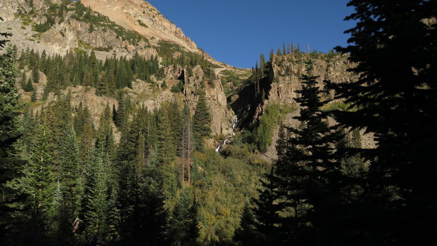
For day three, we planned what would turn out to be an exceptional hike in the Routt National Forest, just north of Steamboat Springs. A scenic ride through rolling pastures terminating in a well traveled seasonal road dumps you out in a typical mountain valley. The headwaters of the Yampa roar out of the hills, as the early summer runoff fertilizes the lush forest. We picked a loop which would bring us counter-clockwise, following Gold Creek to Gold Creek Pond, over an unnamed saddle to the partially frozen glacial Gilpin Lake and back out via Gilpin Creek.
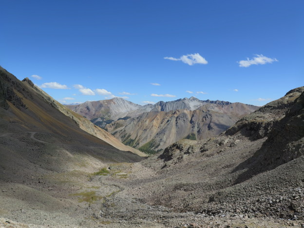
The approach to Gold Creek Pond follows a comfortable grade, frequently crossing the fattened Gold Creek via fallen trees and skillful rock hopping and offering great views into the tumultuous meanders of the creek. The first truly alpine views occur when you emerge from the forest at Gold Creek Pond, a pleasant 3 – 4 miles into the climb. If you were pressed for time, this would be a fine destination. From certain spots on the pond you’re treated to 180 degrees of snowy, craggy peaks. Several massive rock formations dot the shoreline offering great picnic spots. (Turns out it’s also a pretty solid place to propose to your girlfriend!) From here on out, towering peaks dominate the scenery. The average grade increases a bit as you climb up and over the pass on your way to the spectacular Gilpin Lake.

Lest anyone start to think that three’s a charm and that all it would take us to avoid disaster was three consecutive days of adventure, or any such nonsense – hold your horses! As usual, we got off to a slower start that we’d have liked, putting us at high elevation toward midday. As we pushed upward toward the saddle we caught sight of some brutish weather moving in from the south. We weren’t really too keen to turn around and head back through open terrain and toward the worsening weather. On the other hand continuing upward would have brought us into worsening exposure as well. Once again, we were at the mercy of mother nature. As the drizzle steadily picked up, we consulted Backcountry Navigator in search of refuge. From the looks of it, our best hope was a local depression of sparse old growth. The terrain wasn’t too prominent, and the trees were big enough that we hoped they’d catch any impending wrath more preferentially than either of us. Simultaneously, none of the timbers were so close close that they’d frag either of us if struck (I hoped anyway). We hunkered down and trued to convince each other that we were safe.

After enduring some cool drizzle, light hail, and the conspicuous lack of any nearby strikes, the thunder passed by and the sun hinted at re-emergence. It seemed like as a good a time as any, and we continued upward and over the saddle.


Once over the saddle, we were treated to expansive snowfields tumbling down toward Gilpin Lake. It appears as though the snowfields above the lake constantly avalanche into it, leaving little icebergs drifting about well into the summer. From here, literally every direction yields outstanding views of impressive summits, whose nooks and crannies are still draped in blankets of snow. The slippery descent toward the lake reveals that the opposite shore is an impossibly narrow bank which tumbles steeply into the valley beyond, leaving you wondering what force holds the entire thing together.


The remains of the walk bring you steadily downhill through alpine meadows and wetlands with enormous granite walls towering up toward the right, and the raging Gilpin Creek carving a deep trench to the left, mandating one or two icy crossings. Day three complete with no lightening casualties!
Our final day in town was hallmarked by an MTB ride where literally nobodies life was endangered! I did snap a chain half way up the mountain forcing us to coast down into town, buy a new chain, and repeat the first portion of the ride, but this was par for the course by now. In keeping with the 1 Water 1 Coffee 1 Beer ethos, we went directly from biking to the local divey burger joint and got the most indulgent items on the menu, plus the aforementioned beverages. Life is good!