Not Without Peril

Fortunately neither Kelly nor I have made it into any future editions of Not Without Peril, by Nicholas Howe during this weekend’s adventure, but it did serve as a succinct reminder to not underestimate the mountain…

We were up in North Conway for ESAW and though that we should really take advantage of the mountains as long as we were there.  It didn’t seem like there was much worthwhile skiing to be had, so we opted for a hike.  I picked a seemingly benign loop out of Pinkham Notch: Tuckerman Ravine Trail to Lion Head Trail, then south via Alpine Garden and Tuckerman Cutoff, and finally back down by way of Davis Path and Boot Spur Trail.

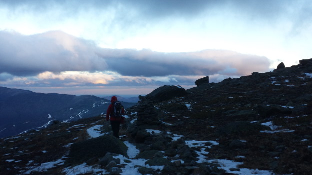
We got off to a leisurely start (11 AM), but made good time all the way until the Lion Head trail.  From there on, it was full blown winter conditions: mud, rock, snow drifts, water ice, and howling winds.  Even with micro-spikes our paced slowed to a crawl.  It took us a solid 3 hours to get to the top of the ridge between the Boot Spur and the summit, and suddenly our notion of a quick 6 mile jaunt began to evaporate.  About half way between the ridge and the treeline on the Boot Spur, the trail takes a sharp dip in elevation and the natural contours offer substantial relief from the wind.  We’d had to shout to be heard for the last hour or two.

With much more ‘enjoyable’ conditions along the Boot Spur I managed to snag a few photos with my phone (the Canon was out for repairs).  Upon emerging from the low clouds, we were treated to a stunning alpine fall twilight.  I tried to savor the view and set aside the prospect of hiking out with about ~2000′ of down-climbing in the snow and dark with just one headlamp.  At around 7 PM we skulked out of the woods and drove straight to May Kelly’s for some protein, whiskey and coffee.  I was tempted to reprise my trademark libations of one water, one coffee and one beer, but I didn’t care for their draft list.  The Irish Mixed Grille hit the spot pretty much perfectly though and the Merry Irishman (coffee, Bailey’s, Jameson) washed it down quite well.

20141109_161700 20141109_161651 20141109_160210 20141109_160203 20141109_160157 20141109_160153 20141109_155858 20141109_155852 20141109_155844 20141109_155835 20141109_155829

Gear List:

Petzl Tikka + Headlamp Grey, One Size Petzl Tikka + Headlamp Grey, One SizeThe Petzl Tikka + Headlamp is a workhorse of a headlamp for outdoor enthusiasts of every kind. This sharp little light provides constant lighting all day long, with three different beams, five modes, and even two modes for the red light. The headband is adjustable and washable, and the housing makes sure the light stays strong in rainy weather.


American Travelers

After staggering back from the lava flows, sun-burnt and exhausted, we were elated to spend the night on a mattress with access to hot running water and a continental breakfast waiting for us the next morning.

17IMG_9045

Luxury!

We crashed at a Hostel in Hilo, where the owner exclaimed to us, “American Travelers!  We don’t get many American travelers…”  Initially baffled, we later reasoned that most of the occupants of the hostel were foreigners, and the fact that we opted to spend our vacation hopping mostly between campsites and hostels must have set us apart from the run of the mill tourist.  I was secretly a little bit proud of this distinction. Anyway, after enjoying our continental breakfast, we embarked upon just about the most run-of-the-mill-touristy day of the entire trip.  We hopped in the car and rode around to see some sights.  In truth, after all of the hiking, biking, diving, camping, kayaking and cold showers, sightseeing was pretty much all we had left in us.  We started in Puna and skipped our way back toward Kona where we would stop at the Kona Brewing company for some post-vacation victory beers and pizzas, before starting the long flight home.  Here’s what we saw along the way.

17IMG_0969

A jungle road in Puna.

17IMG_0968

DCIM107GOPRO

Kapoho Tide Pools

DCIM107GOPRO

DCIM107GOPRO

17IMG_9059

A recreated village styled in the traditional fashion.

17IMG_9061 17IMG_9062 17IMG_9053 17IMG_9057 17IMG_9056 17IMG_9054


The End!

Lava!

For our final big day in Hawaii we endeavored to see some real, live, oozing, flowing lava!  Unfortunately we couldn’t find any, but the trip was amazing nonetheless.  At the time of our visit, Pu’u O’o was erupting (in fact it is still erupting at the time of this writing – you can read about it in the news).  The recommended approach is from the North – you drive through some neighborhoods, park near a trail head, formerly used by geologists, hike through the jungle and pop out near the volcano.  This would have been a modest hike along a reasonably well traveled trail for most of the way, and then some off-roading if we wanted to go look for some lava.  Unfortunately, the damn trade winds were still not in our favor, and we were forced to approach from the South – further round trip, uphill and off road the entire way…

We drove to the end of Chain of Craters road where the old lava flows eventually swallow up the road near the ocean.  The drive snakes through flows from past eruptions and is well worth it for the stark beauty of the barren landscape.  At the end of the road, there is a parking area where tourists stop to check out the lava arches that tumble into the ocean.  This was cool and all, but we had way bigger plans.

16IMG_0948

A small flock of Nenes. These birds are descended from Canada Geese (the honking is quite similar) which became stranded in Hawaii while migrating.

16IMG_0949

16IMG_898316IMG_8986

Before starting our hike we took some time to check out the wildlife and the arches. Pretty cool. We actually were more excited about the Nenes (pronounced Nay-nay) than the arches: signs cautioning us of Nene Crossings and Nene Nestings were literally around every corner, yet we didn’t see a single specimen the entire trip until now. We had started to think they were already extinct and nobody had bothered to remove the signs. In any event we got really excited and took a whole bunch of pictures of them, had a good look at some arches, and then started our off-roading.

16IMG_8988

“Road Closed.” Oh for real?

We used Backcountry Navigator to plot a few waypoints (namely our start and stop points) and started picking our way through the rubble.  Clambering through the lava flow was made our brief trek through Kilauea Iki seem like a walk in the park and we soon began to wonder if we’d bit off more than we could chew.

16IMG_0954

Route finding…

16IMG_0952

16IMG_8998 16IMG_9002

The route was essentially uphill the entire way, punctuated with a few steep escarpments.  The steepest parts of the slope was broken up by patches of surviving foliage, so route finding was more complex than we had anticipated.  We leap-frogged from one pitch to the next trying not to get cliffed-out by the undulating lava flows and impassably dense shrubberies.16IMG_9011 16IMG_9020 16IMG_0957

Atop the last big escarpment, we take a look at our progress – a source of both pride and sorrow.  Backtracking through this labyrinth of crumbling rock would be no easier the second time around.

16IMG_9035

The lava displayed amazing variety in texture, hardness and even color as we traveled across the barren land.

16IMG_0963


Eventually we approached our turn around time – the point at which we would be arriving back to the car after dark if we didn’t head back immediately.  He had no strong desire to clamber down steep lava flows by the light of two headlamps, so we decided not to push our luck.  We did manage to a glimpse of Pu’u O’o, our ultimate destination, but were unable to spot any glowing red lava.  We saw some steamy smoke rising up from the crater and managed to give the optical zoom on my camera a nice workout, but were ultimately defeated.  We’d just traveled one of the slowest 6 miles of our lives and were pretty burned out, not to mention less than excited about the return trip, so we decided to bail.  We set the navigation back to the parking lot and began following the compass back downhill.

16IMG_904016IMG_903816IMG_9044

Even though we didn’t get to see any lava, we gave it the ol’ college try and probably came much closer than anyone else that day.  Taking the ‘scenic route’ through one of the most impassable regions imaginable is always a rewarding experience the memories of the bizarre and tortured land we crossed will be with us forever.

Fall From Different Heights

October is always a month of transition, especially in the PNW. I love the shoulder season, with the crisp Fall air which eventually brings snow and the anticipation of winter. It’s still surprising what a difference one week can make, and a few thousand feet of elevation.

Two weeks ago Catherine and I did the enjoyable Iron Goat loop hike, a 6 mile jaunt. The trail follows the old railroad bed used by early steam engines to climb over Steven’s Pass until the tunnel construction finished. It also officially terminates at Wellington, the site of the largest avalanche disaster in the US, in terms of fatalities. We caught great fall scenery on a relatively clear day! Of course in true PNW fashion, it rain the week before and the week after.

DSC02565

DSC02567

DSC02569

DSC02573

DSC02575

DSC02577

DSC02582

DSC02584

The caboose marks the turn around point, after which Catherine and I hiked the upper railroad grade and detoured to Windy Point. There we enjoyed some great views and met a trail crew volunteer. He told us a bit of history of the iron Goat trail restoration, and helped remind me that next summer I want to be more involved in hiking trail crews to give back and help others enjoy the great hikes out here.

DSC02588

DSC02590

DSC02593

Windy Point used to be a precipitous turn for the railroad, until a tunnel was excavated into the hill the make the turn less sharp and protect trains from winds and weather.

DSC02595

DSC02597

Iron Goat trail was full of remnants of structures, tunnels and history, which you’ll have to go investigate for yourself! I don’t want to give it all away but there was a lot of signage and great stories from the past.

Kendall Katwalk

Last weekend I convinced Tim and Dylan to do a more typical PNW hike-in the rain. We headed to Snoqualmie Pass to investigate the Kendall Katwalk near where Sweeney and I skied last April. The hike was serene, if lacking in views, and we had an awesome time! We also got soaked. We encounter rain, sleet, and heavy snow, with below-freezing temps and lots of snow at the Katwalk.

We knew there was a possibility of laying some tracks in the North Cascades, but I’m glad we did this hike and content to wait a few more weeks until there’s more snow to go crazy over. We’ve got a whole winter ahead of us!

DSC02599

DSC02600

DSC02601

DSC02603

DSC02607

DSC02610

DSC02613

DSC02617

DSC02618

DSC02621

DSC02622

The Katwalk proper looked a bit less striking in the low-visibility conditions. “I think…this is the catwalk?”, I exclaimed as we passed across it. We decided to go a bit further and hang out in a grove of trees to have a snack before descending.

DSC02626

DSC02627

DSC02625

Turning around we encountered a few other groups, and we were glad to have made the first tracks up for the day and have the trail to ourselves for the most part. On the descent the snow, and then rain, really turned up a notch.

DSC02629

DSC02632

DSC02633

DSC02634

DSC02635

DSC02630

DSC02636

DSC02638

DSC02641

With the high country getting hit by snow, this probably marks the last high elevation hike, and the start of touring season on the horizon! Bring on the snow! Here’s praying we don’t fall prey to El Niño.