Tag Archives: National Parks

Iceland Adventure

Catherine and I spent 8 days in Iceland, driving about 1400 miles on and around the Ring Road. We did some great sightseeing, hiking, and had time to unwind, all while enduring the unseasonably cold temps and winds. Catherine put together a video of the trip here. I took way too many photos, some of which I’ve put up here.

I’ll try to describe the trip from my journal notes while abroad. I’ve included a few highlight photos for your viewing pleasure.

Day 1 – Keflavik to Selfoss

After worrying about our plane tickets, our flight went smoothly. Then, disaster struck when we arrived at 6:30am. It took us nearly two hours to track down the company in charge of our car rental, since our rental agency was actually a booking agency, but they’d never told us which company had our car.

Things started to turn around after we left the airport. We drove close to the city and had no issues buying groceries. We doubled back and were able up move up our Blue Lagoon reservation. Though man-made, it was unique and relaxing. We napped after a dip for a few hours, until we could check in at our hostel. On our way to Selfoss we saw our first sights, with Catherine in the driver’s seat. Iceland is barren! Lots of snow and rocky carved cliffs. Our guesthouse in Selfoss was well equipped and provided a great base to catch up on sleep.

DSC03203

Day 2 – Selfoss to Höfn

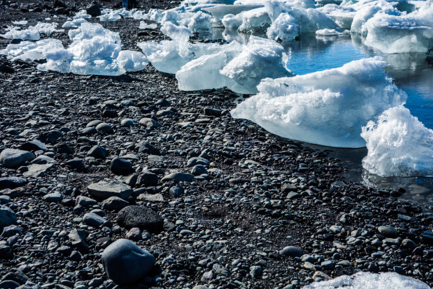
It was a big day. We started early around 7:30. First stop, Skogafoss, pictured above. It was icy and roaring. I ran to the top for some more photos. It’s also the start of a big hiking trail to Porsmork. Next was Vik and the black beaches. It reminded my of our first PNW trip. Afterwards came mountains. And more and more, endlessly. We skipped Svartifoss because the trail looked lame, and we’ve seemed a lot of falls, and instead drove to the glacier nearby. It was hidden just off rt. 1 behind a hill. I took over driving there. Onward to Jökulsárlón! I was rusty at manual, but no stalling, despite limited previous practice. At the lake we saw Marcus and his brother, who’d sat next to us on to plane, on a random embankment. Crazy huh? Our hostel was perfect. Very private and we were the first guests ever in a new addition. Our hostess helped us with laundry and we had a big breakfast!

DSC03195

Day 3 – Höfn to Berunes

We went into town for the morning. Then, nothing but mountains and coast on our drive along the fjords. We also found moon-like terrain. Very cold and windy all day. We stopped a lot and listened to powerful surf. Before Berunes we drove into town and found a store with dragon bones out front. There we played fetch, heard stories, and bought handmade souvenirs. The hostel had been run by the same family for 300 years. The old guy running it was awesome. We went for a frigid walk in the evening to the beach. In the morning we were served breakfast at our host’s house.

DSC03292

Day 4 – Berunes to Akureyri 

Catherine’s birthday! Also, a long, snowy, whiteout drive. We passed Dettifoss and Mývatn since the visibility was so bad, but stopped at Godafoss. Akureyri was crowded, but our Airbnb was awesome. Lamb, Einstök beer, and Toblerone cake for dinner.

DSC03355

Day 5 – Akureyri to Reykholt

We headed to our last minute booking at Hotel A. The drive took us longer than we expected. We found Catherine’s mountain spire and a new falls. Lot’s of roadside photos. Hotel A was quaint and quiet. A herding dog befriended us and we spent hours by the fire sipping beer and reading.

DSC03835

Day 6 – Reykholt to Hellnar

We slept in, got breakfast and headed out. The assistant at the hotel pointed out some nearby landmarks and we were off. First to Barnafossar, above, then past a hot springs, and back to 1 and Arnarstapi. Great views on the way. We stopped at the black church in Búðir. We were relocated from Snjofells to Hotel Hellnar. After this discovery we drove down the coast to Lóndrangar, a sea stack alone on the shore that had drawn some climbers. We took a long walk there and in Arnarstapi. Mussels for dinner were delicious, and after we smuggled beer into our room while we played Rummy and read.

DSC03996

Day 7 & 8 – Snæfellsnes Peninusula to Keflavik

We had two nights in Hellnar, so the second day we drove the peninsula, soaking up views of the Snæfellsnesjökull, pictured above, which dominated the area. The glacier is said to be one of the seven power sources of the world. We climbed a volcano, walked around an ancient viking village, and found yet more waterfalls. The wind whipped at us in the open spaces, threatening to knock us over at times. We drove to Grundarfjordur and snacked there, before doubling back over the lower mountain pass. On our last day we tried to make it to an archway between Hellnar and Arnarstapi, but needed to hit the road to make our afternoon flight.

Iceland was stunning, and varied. I’ve never been to Hawaii, but it felt like the opposite of a tropical volcanic jungle. Iceland had the beaches, and active volcanoes but was certainly no tropical paradise. Our only regret was not seeing the green pastures and spring growth delayed by the cold.

See many more photos here! Thanks for reading.

Camp Muir Classic

Sean, Tim and I did some mid-summer skiing just about a week ago. We day tripped over to Mt. Rainier and though we didn’t really luck out with the weather, we had a great time.

We got a reasonable start at Paradise, with plans to take it as we went, and immediately ran into this:

DSC03110


Thick fog the whole tour up.  Luckily the NPS and guide services had kindly flagged the standard route to Camp Muir the whole way up, and I was somewhat familiar with the mountain from my last visit.

DSC01940


Our best view until we broke the clouds, the Nisqually terminus below Panorama point. We made good progress up the first half of the tour, but began to slow down through the multiple transitions, and lack of visibility. The whole Muir snowfield is fairly safe in good weather, with many parties ascending and descending, flags, and fairly distinct ridges to either side. Nevertheless with poor visibility, we stuck together to took it slow and steady, especially with the recent accidents on the mountain.

CameraZOOM-20140629111823572

CameraZOOM-20140629111903421

Tim snapped about half the photos of the trip on his own camera.

DSC03098

Sean and I during a snack break.

Higher up, we continued following the well-worn path and flags, without much change.

DSC01942


DSC03100


DSC03101 DSC03107 DSC03102

We were getting a bit demoralized by the fog, and weren’t originally planning to go all the way to Muir, but heard Muir was only a short ways ahead when my phone died ~8700 ft. Just as we were cramping up and having thoughts of stopping, we broke through the clouds.

DSC01943

We trudged the last bit up to the Camp and took it easy for awhile at 10,000 feet. Finally we got some well deserved views. It was fun hanging around. Other groups were mainly camped out, with a few other skiers getting ready to descend, who kindly took our picture.

10463648_10152146215960423_2233789435524762259_o


DSC03118 DSC01952 DSC01955

After some rejuvenating snacking, we geared up for a slow descent into fog.

DSC03139

The first 20 or so turns were creamy, and fresh from a few inches the night before, making the whole thing worth it.

DSC03136

Sean heads off.

DSC03147

Me vs. the fog.

DSC01976

Tim coming to join us.

Then it was back to fogginess and low visibility, which meant, follow the flags and tracks, and stick together.

DSC03150

We got slightly separated at one point, since visibility was that bad, but met up fairly quickly at the next transition point, and stuck together the rest of the way back to Paradise, marking just about a 5k vert day.

On our way out, we saw some local wildlife.

DSC03161

Of course the clouds were hanging right at Paradise, so descending down the mountain held some great views.

DSC03170

On our way home, the weather decided it was about time to clear up and become gorgeous.

DSC03183

And finally, we were back to Seattle.

DSC03187

See you guys on the next tour!


June-uary on Rainier

For the first time of my life, I’ve skied a volcano.  It’s a cool thought, although many people make the trip to Rainier, and yesterday was no exception.  After eye-balling topo-maps, NWAC, and talking with a local shop, I decided to head to Rainier solo and see what it’s all about.

I’ve learned that even when conditions in the PNW are lame, Rainier can still be good, and it was awesome corn skiing…in January.  NWAC was reporting green light conditions due to warm temps and consolidation, along with blue skies.

Upon arriving, I learned the stories I’d heard were true.  The Paradise gate is locked until 9 a.m.  A bit unfortunate, but it gave me time to gear and wake up.  My intended trip plan was to stick to the classic Muir Snowfield route, and follow some people up.  It begins at the Paradise parking lot, which is at ~5400′.  Luckily I met Jeff and John who were great company and we veered slightly off the beaten path onto some variations of the route.  It was also the maiden voyage for my Movement Response-X skis, which I was quite fond of by the end of the day.

DSC01269-edit

Our first look up at Panorama Point. Our route took us left around behind the rocks and shrubs to the climb.

DSC01280

Booting up. Almost broke out the boot crampons here. Ski crampons were used later.

Jeff and John on the point.  Snack time.

Jeff and John on the point. Snack time.

DSC01272-edit

The views were pretty good, too.  Mt. Hood is visible on the far right.

More booting.  I switched back to skins + crampons.

More booting. I switched back to skins + crampons.

It was a gorgeous day, and by the afternoon temps on the mountain were ~50 degrees.

Rainier, up close and personal.

Rainier, up close and personal.  The Nisqually glacier is front and center with the chutes on lookers right.  It was great to finally get a closer look than staring at it in the distance from the city, or even Crystal.

Things were looking good as we neared 8600′, give or take a bit.

DSC01299-edit

Adams as the backdrop as we neared our transition. We also got a good look at Mount St. Helens.

One more look at Rainier.

One more look at Rainier.

We hugged the other side of the ridge from the Muir Snowfield up-track, away from the masses, careful not to dive too far skier’s left down into glaciers.  Suddenly the views we’d been getting sank in and I realized, man, Rainier is huge!

DSC01292-edit

John, with some incredible relief behind.

The first few hundred vertical were decent, though the Movements made for a bit of a bumpy ride on uneven wind-scour.  Then it turned to sweet corn and it was grins all the way down.

DSC01291-edit

McClure Rock face. I quickly measured it with the ol’ inclinometer at 52 degrees +/- human error from where this photo was taken.  Steepest face I’ve skied in awhile at least.  You couldn’t see much but the bottom while looking down on it.

John and Jeff had some fun on a steep face, which may have been slightly iffy, if there hadn’t been a few tracks and a snowboarder landing into it sideways, then side-slipping half of it.

DSC01309-edit

DSC01329-edit

The Movement’s performed excellently on steeps, corn and firmer snow.  I almost forgot what it’s like to lay over a ski narrower than 100mm underfoot.  I was able to ski confidently on them at speed, and the flex didn’t feel weak or too soft.  We’ll have to see how they perform in powder, whenever we get some more snow in the PNW.  And another thing, the mixed skins from Movement felt great.

The trip took us approximately from 9:45 – 3ish.  Jeff broke out his goPro so there may be some footage out there in the works.

An awesome introduction to Rainier!

Olympic Coast Overnight

With our National Parks re-opening (after much outrage), I thought I’d recount a hike Catherine and I had been wanting to do since we were planning our June Seattle/Portland trip: Backpacking the Olympic Coast.  Due to its relative remoteness, it deserved at least the two days we gave it, and offered a good deal of solitude.

We check the tides and arrived near the coast to hike a section of the “Wildcatter” shore.

Andrew on the beach

The beach near the trailhead.

Our plan was to beat the incoming tide, and the hike to high ground until we reached our campsite.

DSC01202-sm

After much scrambling, we reached a pebbly cove.

Catherine hanging out, surveying the numerous sea stacks.

A view of the cove. I had to give up my walking stick already.

We quickly arrived at a very steep ladder switch-back, which we had luckily read about.  We also encountered our first mud of the trip.

Catherine, perched in the middle of the ladder.

Our route took us over Hoh Head, and then lead us into thick brush, despite being an old trail.  We also encountered more types of mud than a Tough Mudder course.  Tiny spiders seemed to enjoy making their webs across the trail, which we had to keep swatting away.  Constant glimpses of the shore kept us motivated, though.

photo 4(1)

photo 2

Because of the tides and the travel distance we’d gotten a late start, so we set up camp as the sun began to set.  Luckily this lead to some amazing views.

Sunset at Mosquito Creek

As the sun dipped below the horizon, distant sea stacks came into view. I think they might be part of the Washington Islands Wilderness.

Sleeping wasn’t too cold yet and we very comfortable under our Ray-Way quilt, sewn by Catherine’s mom.  It was our first backpacking trip with it, and though light, the synthetic bulk took up a bit more space than carrying two summer down bags, but also warmer.  I think if my pack was 36-40 L (including rolltop) and under 2 lbs, it would fit better than in my current 31 L.  Luckily, everything fit, even with the added bearvault we were carrying.

The next day we packed up and doubled back, since we didn’t have a car to shuttle us from the other end.

It was a great weekend hike, that was over far too quickly!