Tag Archives: photos

Winter Readiness: Black Diamond Factor AT Sole Block Install

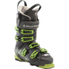
In the spirit of the recent post regarding testing my winter load-out, I decided to document my various winter preparation activities just in case any of this eclectic trivia or minutia should be of use to anyone else out there. (And judging by the searches by which people seem to arrive at this site, at least some of this might be useful information…) So, here’s the first topic in the Winter Readiness series: How to install a set of AT Sole Blocks on the Black Diamond Factor boot.


First, let’s have a quick look at all of the moving parts:

Exploded: Boots, blocks, hardware, liners.
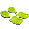
Close up: the alpine blocks to the left, the AT blocks to the right and
the included hardware in the center.

I’ll assume most people will have purchased the boots with the Alpine block pre-installed (at least that’s what happened in my case).  In any event, the process of removing and replacing the either set of blocks is identical.

The first step in removing the sole blocks is to unbuckle everything, remove the liner, yank out the boot board, and flip them into walk mode, just for some extra wiggle room.

Das Boot.
Unbuckle and unstrap.
Remove liners and boot boards.
Flip into walk mode.

The next item on the agenda is to remove the alpine blocks by unscrewing them and prying them off of the boot.  Let’s first take a closer look at the hardware involved.

Button heads with #2 Philips fittings and flat heads with Allen wrench
fittings.
Number 2 Philips driver, included Allen
wrench, a hammer, the screws.

To remove the toe pieces unscrew the two machined flat heads near the toe welts using the included Allen wrench.  Pry upward on the toe welt of the sole block.  With enough force it will pop loose, allowing you to pull the toe block backward and completely clear of the molded plastic fittings.

Unscrew with Allen wrench.
Pull upward on the toe welt.
With the toe loosened, pull back on the entire block until it breaks free of
the molded plastic fittings shown below.
One down, four to go!

Next step: remove the heel piece.  This requires that you locate the two #2 Philips head screws under the boot-board and back them out.  Once this is accomplished, you can bang the block off of the boot with a few carefully placed hammer swings.

Back out the two heel piece screws.
Hammer the heel piece off.  Fairly careful aim is required to have any effect:
you want to be sure to strike only the heel piece or else the sole of the boot
will absorb the force rather than the heel block.


Enlarge to see the heel block has slid off of it’s molded fittings on the boot.
It can simply be pulled off now.

While you’re at it, you should probably repeat this process on the other boot.  Now to put the AT blocks on.  Let’s have a close look at those:

A careful inspection of the sole blocks reveals that each is labeled with a
capital R or L

We’ll start with the toes.  Be sure to grab the correct block.  Fit the rear portion of the toe block over the plastic moldings just forward of the middle of the boot – they should hook on.  Once the rear of the toe block is firmly hooked on, press down on the toe block over the toe welt until it snaps into place.  Finally, the toe piece can be locked down using the two flat head screws fitted for the Allen wrench.

Place the heel block over the plastic moldings and press forward until the
toe piece is firmly seated.


Press down over the toe welt until the toe block snaps into place.
Lock it down using the two flat head screws with the Allen wrench.

Next step: the heel block.  Grab the appropriate heel block and slide it forward ensuring first that the forward grooves are seated correctly, and second that the rearward grooves follow into place.  You should see any gaps between the heel piece and the boot if this has been done correctly.  You may need to persuade the heel piece into position with a few hammer swings.  Once it’s in place, you can drop the two Philips head screws into place from the top of the boot and crank them down using a #2 screw driver.

Slide the heel block over the molded grooves near the boot center, and then
be sure that the rear grooves have followed into place.
You need to exert a bit of downward pressure to keep the grooves lined up.
Finally bang things into place with a few hammer strikes.
Replace the two Philips head screws and tighten them.

Repeat this process on the second boot.  Replace the boot boards, the liners and buckle things up again (boots keep their form best with all buckles and straps secured during storage).

Done!

And with one less Winter Readiness chore checked off my list, I think I’ll kick back with some light Sunday afternoon reading…

Should be a good winter!

Gear List (click links for more product info):
Black Diamond Factor 130 Alpine Touring Boot - Men's Black/Envy Green, 27.5Black Diamond AT Sole Block Envy Green, L Free Shipping on Orders over $50

Winter Readiness: Winter Expedition Loadout

With winter fast approaching (October is next week, November = ski season!!!), I’ve been stocking up on various new gear items and thought it was about time to see that they all actually work together.

In particular, I recently wangled a GoPro, chest harness, and spare mount kit at a stupendous discount.  I kinda don’t want to mount it to my ski helmet for a few reasons: it’s completely outlandish looking, and I hear it tends to pop off if you wreck really hard.  So, I decided to spring for the chest mount.  My major concern with this decision was whether it would actually fit reasonably well with all the rest of the stuff I expect to be wearing if I’m actually skiing some place worthy of the GoPro.  Despite the stifling, disheartening, and entirely unseasonable temperatures in Boston lately, I got decked out in just about every piece of technical gear I own to see whether or not this is even feasible.


If I’m really out in the sticks, the avy beacon is a must have.  So that went on first.  One can imagine the gnarliest backcountry skiing trips, involving various bits of mixed climbing or traveling over glaciated terrain (for what it’s worth I’m no where near this stage of competence, but one can imagine such a scenario), so I jumped into my climbing harness.  Next, I threw on my shell jacket for purposes of realism.  On top of the jacket goes the Avalung II; after all we’re talking about slaying epic backcountry lines here, not cruising around on inbounds groomers…  Now for the centerpiece: the GoPro with the Chesty.  This works considerably better than one might imagine.  The Avalung is actually kind of flat in the center, providing a level vertical surface on which the chest harness can rest.  And finally, for good measure, I put on my winter day pack.  In some small miracle, none of the straps seriously interfere with each other.  Mission accomplished!  As an added perk (an operational necessity, in fact), I discovered that the climbing harness and beacon are both still entirely accessible without removing anything, but by unzipping the bottom zip on my shell jacket.  Ready for action!

Decked out.  The big bulge in my midsection is the beacon.
The beacon and climbing harness hardpoints are available by
 unzipping the bottom zip and unbuckling the hip belt. 

Gear List (click links for more product info):
Black Diamond AvaLung IIBackcountry Access Tracker DTS BeaconBlack Diamond Chaos Harness Ink, MBuy GoPro HERO Camera at GoPro.comFree Shipping on Orders over $50

Pemi Loop

After an entire week of sweating my face off around Boston, Rob, Shane and I figured it was about time to head back up north for some cooler climes, fresh air and good old fashioned exercise.  The plan came together at the absolute last minute, with details lacking finalization until some late hour of Friday night.  Per usual, we reasoned that we’d better stock up on calories, so we hit the town in search of beers and burgers.  Around midnight we skulked back to our respective apartments, set our alarms for 6:30 AM and crashed.  Shortly after 7 AM we all rallied and set off for Lincoln, NH.

For those not familiar with the Pemi Loop, familiarize yourselves:


View Pemi Loop in a larger map

View Pemi Loop in a larger map

Ok, so here’s what you’re looking at.  The Pemigewasset Wilderness (or Pemi, for short)  is the large tract of land between I93, the Kancamagus and Rte. 302.  In many cases, the word wilderness might seem a bit overstated.  In the case of the Pemi, not so.  There are many places in the Pemi that are basically a day’s hike from any sort of civilization with the only mode of transport being your feet.  When you get out there, it actually feels like you’re in the middle of nowhere…it’s cool!  The Pemi Loop is a 36 mile loop of trail, which essentially surveys the whole Wilderness.  Much of it overlaps the AT and most of it is at elevation.  In fact, only the 7 or 8 miles on either end of the loop are spent below 3000′.  Totaling about 36 miles, the route is frequented by trail runners looking for a challenging, single-day distance run.

By contrast, we opted for a more casual two day pace: about 14 miles on day one and the other 20 or so on day two.  We tried to pack as light as possible by bringing various ultra-light gear.  Rob and Shane each used a Hennessy Hammock and I used my Sprite in it’s pitchlight configuration.  We each brought summer sleeping bags, ultra-light mattresses, food, rain shells, water/purification equipment, and minimal miscellaneous equipment.  I somehow managed to fit all of this into my North Face Off-Chute 26, all weighing in at 19.8 lbs!  I’m sure people have gone farther with less, but I was pretty proud of myself…

We hit the trail about 10 AM on Saturday morning.  The first few miles are an easy cruise along a former railroad bed.  Eventually you come to the Osseo Trail which heads uphill toward the backside of Mt. Flume and Franconia Ridge.  This is basically the last time you’ll be anywhere near the valley floor for the rest of the hike.  We thought this was great for a number of reasons.  Escaping the heat was certainly a concern.  Gaining elevation quickly and hanging onto it for as long as possible tends to do wonders for morale – it seems as though you’re storing up potential energy that way…  But, perhaps of greatest importance was the outstanding view of the surrounding wilderness offered from the high ridges of the Pemi Loop.  One of our highest priorities on this trip was to produce as much documentation of ski-able backcountry lines as possible for the winter.

After a quick perusal of  the incredible amount of photos and GPS data we collected, I realized that the ski beta probably deserves a post of it’s own.  So… the rest of this entry will be a straight-forward trip report from our Pemi Loop excursion and a follow-up entry will recount all of our ski recon in a more concise and dense format.

And on that note, I’ll let the photos do the rest of the talking…

Rob and Shane at our first break about half way up the backside of Flume.
As it turns out the back is nearly as steep as the front…

Franconia Ridge: Lincoln and Lafayette
Rob atop Liberty with the ridge in the background.
The Ridge north of Lafayette.
Our campsite should be down in there some where…

Our campsite with the days progress in the background:

View Pemi Loop in a larger map

It took us a lot longer to get from Lafayette to Garfield Pond than we expected.  You always intuitively expect the descents to be easy and fast, but frequently, as was the case here, the steep challenging terrain causes you to go even slower than the same slope would were you going uphill rather than down. It didn’t help that we had just climbed four mountains plus like three false summits.

As we got closer to the pond we began to worry that it might be obscured by dense trail side brush and that we might miss it.  This concern turned out to be unfounded, as the pond is easily visible from the trail.  In fact there are a number of reasonable (but totally unofficial) camps on either side of the trail right next to the pond.  Just to be on the safe side we used an an altimeter in conjunction a topo map to get our rough location.  For maximum accuracy, I was able to use Backcountry Navigator on my phone which uses the GPS and pre-cached map tiles to pinpoint your current location.

We arrive just before sunset and make our first priority water…

Rob and Shane at work with the water filter.
As usual, the water filter proved to be kind of a pain in the neck.  When my MSR Sweetwater filter met it’s untimely demise on the Long Trail last summer, I replaced it with the MSR Miniworks.  This model is slightly bigger and heavier, but is 100% field serviceable.  Every single part can be removed without the use to any special tools and the filter element can be cleaned with a simple piece of steel wool, included in the kit.  The pond was a silty mess, so we had to clean the filter a number of times and use the float to keep the intake away from the floor of the pond, but we ended up with plenty of water eventually.
Dusky pond.
Sunset begins over Garfield Pond.
Sprite 1 Pitchlight: ultralight summer
comfort!
The Hennessy Hammocks: pitch anywhere and sleep in
comfort! 
A pretty solid sunset ensued…
Ideal ratio of clouds to clear sky for
maximum sunset action.
Rob hoisting the food into a tree for the night.
We awoke to wisps of cloud drifting across the pond.
Looking back toward Franconia Ridge as we make our way up Garfield,
early Sunday morning.
Our first summit of the day: Garfield.
Same thing…
The Pemi from just below Garfield.

Owl Head and The Pemi.
The precipitous scramble down from
Garfield, and a good example of why
descending frequently takes a long time.
The ridge up on top of Guyot.
The three of us at the summit of Guyot.
Bondcliff.
More Bondcliff…

Rob surveying the land in epic fashion.

Ditto…
After the dramatic West Bond and Bondcliff ridgeline, the trail descends at first steeply, but gradually mellowing, back to valley floor of The Pemi.  It’s not a bad hike, but by this stage of the game it seemed to drag on forever.  We eventually shambled our way out of the wilderness (well Shane and I did some shambling; Rob somehow marched out with the cadence of a soldier fresh out of bootcamp, apparently undaunted).  We threw all of our smelly junk into the back of the car and set off in search of steaks.  We found just what we were looking for at Gordi’s Fish and Steakhouse in Lincoln in the form of 20 oz steaks, all you can eat salad bar (which in our case was more like all you can eat fresh vegetables and other toppings with a bit of lettuce for good measure) a potato each and some complimentary loaves of bread.

Gear List (click links for more product info):
Black Diamond Contour Elliptic Carbon Trekking Pole Ink Blue, One SizeKUHL Trek Short - Men'sMountain Hardwear Sprite 1 Tent 1-Person 3-Season Humboldt, One SizeMountain Hardwear Sprite 1 Footprint PLMountain Hardwear Typhoon Jacket - Men's Cypress/Duffel, LMSR MiniWorks Ex Water FilterAsolo TPS 520 GV Boot - Men'sPetzl Tikka XP 2 Headlamp Graphite, One SizeTherm-a-Rest Prolite Plus Sleeping Pad Pomegranate, SFree Shipping on Orders over $50

Peak-bagging and Summit Beers

Freshly warmed up from Mt. Monadnock, and thoroughly convinced that there’s no ski-able snow left in New England, Alex and I geared up (read: had huge dinners and a few beers) and rolled up to Lincoln, NH to crash early and get a fast start for a long hike in Crawford Notch.  We wanted to do something long and fairly challenging, with some decent rewards, but avoid the Memorial Day hordes.  This turned out to be the perfect solution: the plan called for nearly 17 miles, over 8000′ elevation change, it’s remote compared to much of the Whites, and our early start and rapid pace nearly guaranteed few encounters with any crowds.


View Avalon, Field, Willey, Webster in a larger map

As usual, we got off to a slower start than we hoped for, most likely owing to general morning grogginess and a pronounced need for some White Mountain Bagel before seeing any real action.  Still, we managed to hit the trail at 10 of 7.

We set off at a clipping pace up the steep Avalon Trail, out of the AMC Highland Center.  The Avalon Trail goes pretty much straight up, without relenting until you pass Mt. Avalon, where we took a brief detour to play with my camera’s new smile auto-detect feature.  We experienced mixed results.  Next time I think I’ll just go with a tripod and 10 second timer…

Alex tries to figure out what it takes to trip the smile detect.
We gave up and did things the old fashioned way.
Photo Credit: Alex

With all the serious climbing of the morning out of the way we sped off toward Mt. Field.  The trail dips down and up again between Avalon and Field but is considerably easier traveling than the route up from the Highland Center.  The trail wraps around the west flank of the ridge yielding impressive views of the Pemi Wilderness.  Without much trouble we summit Field and push on toward Willey, the final stop before descending toward and the crossing back over Rte. 302.

Willey offers some great view and some nice rocky spots to hang out and relax.  The sun was starting to get pretty high, and the morning’s haze and mist were starting to burn off, so we decided it was about time for Summit Beer Number 1.  Turns out it was a good chance for some more photos.

Some of these slides have to hold enough snow to be
ski-able.  Let’s hope a 3-degree file guide and some diamond
stones find their way into next year’s Christmas Stocking.
302 Snakes along the Notch floor.
Summit Beer Number 1.  The
Sam Imperial White seemed like a solid bet
in terms of slaking our thirst  on a humid
day in late spring.
Nature.
Clouds culminate over Mt. Washington.
A sweeping view of the Notch.
More backcountry skiing recon missions.
Danger to fun ratio: acceptable.
Once refreshed and rested we set off back down toward 302.  The way down along the Kedron Flume Trail may be steeper than the way up in many places, and it’s challenging, but with a stiff pair of telescoping trekking poles you can really cruise down this trail.  We stopped for a few more quick photos at the flume and then again shortly there after as we crossed the Conway Scenic Railroad.
Jose chillin’ atop the flume.
Just plant, dammit.
Photo Credit: Alex
Alex stands his ground over a
modest railroad trestle.
We emerge from the woods on of the Willey House, a gift shop and ranger station at the crossing of 302.  We fill up on water, change into fresh socks, eat (Alex had an ice cream) and steady our nerves for the next big climb or the day: Webster by way of the Webster Cliff Trail.  We cross the highway, and head back into the woods, roughly following the Saco River toward the shoulder of the cliff, at which time we head more or less straight up.  The Avalon Trail is no joke, but the first mile or so of the Webster Cliff Trail is a real kick in the pants.  Numerous switchbacks notwithstanding, it relentlessly crawls up to the top of the cliffs.  By the time we approach the ridge my quads are starting to cramp up and Alex is working on some Long-Trail-esque blisters.  The arduous climb eventually gives way to an exciting ridge walk; not as exposed as Franconia Ridge but every bit as fun.  After a quick look around we move out.  
The view to the southwest just after cresting the ridge.
Alex surveys the Notch looking north west back toward the
Highland Center.
We charge ahead toward Webster, eagerly anticipating Summit Beer Number 2.  By the time we arrive at the summit of Webster, we’re starting to wonder if summiting Jackson is entirely necessary: we conclude that we actually have a superior view of the surround land from Webster and decide to can the extra 1.5 miles and beeline for the Highland Center, but not before fueling up and snagging a few final photos.
Him again…
Photo Credit: Alex
This bird was completely undeterred by any of our noise
making.
Photo Credit: Alex
We speculate that he followed our scent across the Notch.
Photo Credit: Alex
Mt. Washington and the Souther Presidentials from the
summit of Webster.
The Mt. Washington Hotel.
A brief respite the Highland Center, just past 5 in the evening.
Gear List:

Asolo TPS 520 GV Boot - Men'sBlack Diamond Contour Elliptic Carbon Trekking Pole Ink Blue, One SizeBlack Diamond Traverse Ski Poles