As a long overdue follow-on to last year’s post Long Day on Long’s Peak (anyone else enjoy that play on words?), I present Long’s Peak: Keyhole Route. I’m continuing with a couple themes that I’ve latched onto recently.
Google Earth flyovers – I don’t have a helicopter or a RED Digital Cinema camera so you get this instead. I think it’s cool looking and it adds some context…
Some semblance or story arc. Alright maybe that’s a stretch, but the idea here (seen also in Castle Peak and mostly not seen in any of my skiing stuff) is that a solidly good, 1water1coffee1beersort of day has a beginning, middle and end during which we travel through a variety of moods, conditions, and settings; almost like a miniature epic…
Playlist format – saves me from feeling quite as bad when I have to cut 98% of the footage but allows for at least some of it to be narrowly focused and less indulgent than I often tend to be because I can include a few extras that would otherwise be gratuitous in an amateur short video.
Alright enough blabbing! Full-screen, volume up, and draw the blinds a bit – best viewed with no glare!
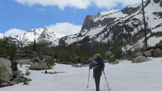
It occurred to us the other day, that for some reason we haven’t been backpacking once yet in Colorado! Clearly this was unacceptable, so Kelly picked out a nice warm-up outing so we could get our backpacking legs under us for the season. We booked a spot at Ouzel Lake, which has an upper and lower site. The lower spots were filled so we settled for the upper sites. The upper site is a tad farther from the trail-head, though in either case the whole walk would have been roughly 10 miles round trip. Would have been…
We’ll return to that thought in a bit. Before all of that, we travelled over a gently climbing and well maintained trail that hugs the St. Vrain and then the Ouzel Creek, through sparse pine forests, over several aesthetically appealing timber bridges, past raging cascades and eventually onto a thinly treed ridge offering 360 degrees of views, at least 270 degrees of which are spectacular.
…And as you can see above, the trail was ultimately smothered by an expansive blanket of snow. The well traveled bits and the sun baked parts were plenty supportable and we hardly needed our spikes. In fact, all was well until we lost the trail somewhere after the lower camp area. No worry; we’d just use Backcountry Navigator and the USGS tiles I just downloaded for the region that morning. We navigated back toward the trail and followed it up hill and into the woods through increasingly deep snow and steep terrain until we found ourselves standing atop a snow-bridge under which the Ouzel Creek roared savagely in the spring melt.
After Kelly briefly dipped a foot in the water we agreed to follow the trail as closely as we could without crossing any buried water. We bushwhacked further up a convoluted pine forest that would have made for an absolute playground of midwinter tree-skiing: constant pillowy undulations, and perfectly spaced trees. We navigated off trail through cliffbands and around snowy canyons until we were approximately to the location marked on the map as the upper campsite. After a solid hour of travel, we had covered only one mile. Bushwhacking in shin deep snow is no joke!
A second, third and maybe fourth look at the map revealed that we should have been standing in the creek. Indeed, we were standing on a small ridge running east-west. The creek emerged from a cliffside roughly to our north, and traversed under us to the south. We pondered this paradox briefly before concluding that we were standing on a massive snow drift (25 feet deep at least!?!?!) with running water below.
We realized that the campsites were essentially no more find-able than the trail, so we backtracked down toward the lower site. The lower site was in a similar state of affairs. No gargantuan snow drifts, but all low lying, flat terrain was buried in who knows how much snow. At least it was flat. Somewhat indifferent with defeat, we settled on the first level spot, threw down our packs and made camp.
Turns out, the spot we arbitrarily settled on could hardly have been better. Water was close at hand, and the views in either direction were great. We feasted, set up some time lapses, shot photos, strolled about and crawled into bed as soon as it was acceptably late. A nocturnal bathroom break yielded absolutely still air, a brilliant half moon, and surprisingly good visibility – no headlamps needed really, even though it was the middle of the night.
It must have been below freezing for most of the night, because the snow firmed up as soon as the sun set. Around 3 or 4 in the morning my 45 degree back became a little bit inadequate so I pulled on a down jacket snoozed happily until the sun woke us both in the morning.
When we crawled out of bed, our boots, socks and packs were covered in a light frost, which evaporated almost as soon as the sun hit them. The hike out was fast and cool in the morning air. In a couple of hours, backpacking number one was in the books and we were on our way to après-hike Mexican food.
Similarly spectacular, but an order of magnitude more perilous, hike number two is in the books for Brian and Kelly in Colorado: Season 2. Objective hazards don’t really eat at me all that much. A long climb in no-fall terrain, for example is cut and dry: be careful and don’t fall. Or storm skiing in the backcountry: stay off the steep slopes or anything attached to a steep slope. Risk mitigated. It’s the stuff that you really have no control over – no effective means of mitigation – that freaks me out.
What to do about lightning… Run for cover I guess? A dubious proposition at best, if above treeline. Or in an an expansive pasture which extends for miles in all directions. I suppose the best you can do is make haste downhill until you find yourself surrounded by old growth where the chance of being directly struck or of being fragged by a Lodgepole Pine whose impedance was a bit too high to transmit 100 million Volts is reasonably remote is really your only recourse.
Yikes!
We checked the living daylights out of the forecast, saw that there was a chance of showers and thunder around 2PM and settled on a turnaround time of noon. We hit the trail at quarter to 9AM, summitted at or before 11AM, took stock of the brooding, dark clouds, and hightailed it out of the alpine. As soon as we hit treeline we were greeted by an unmistakable blue-ish flash and a near-contemporaneous crack. We hit the deck, no doubt far too late to make any difference to mother nature, cinched up our pack suspensions and hauled ass downhill as fast as wet snow and micro-spikes will allow. Our new friend Rolling Thunder followed us downhill for a good mile or so before we began to feel comfortable with the level of risk.
To make a long story short, we were not struck. We did, however, capture some cool pictures of the ominous skies and swirling clouds between running for our lives and wondering whether or not NOAA is to be trusted in the future…
Hinge season in Colorado Rockies! Honestly, I usually have a tough time with the end of winter, but between the great hiking conditions and steep skiing opportunities, there’s not much to complain about.
A couple weeks ago Kelly and I shot up to RMNP for a casual hike out to the Loch. You depart from the Glacier Gorge trailhead off of Bear Lake road and follow a moderately ascending trail past numerous stunning vistas. Herein lies the magic of hiking in these parts: in New England (what I’m used to, and my point of reference for much mountain-sport), grand and sweeping views are usually only had at the top of a mountain. Out here, with the relatively thin foliage and close proximity to treeline, you quickly find yourself in the realm of the breathtaking. Thus, a casual stroll uphill terminating nowhere near the summit of anything can easily result in scenes worthy of Ansel Adams’ attention. It’s almost too easy!
So what do you get for 1200′ of climbing over ~3.5 miles? Behold!
A post shared by Brian Sweeney (@briangsweeney) on
That’s the frozen Loch where we had lunch and took in the view for an indulgent length of time: it was like 60 degrees after all! For the more ambitious, it’s possible to proceed up the ravine toward Sky Pond which is supposed to be equally beautiful, but we were satisfied our first hike of the season and turned around here.
My usual M.O. for drafting these posts is to present media in chronological order, or occasionally to organize photos and videos for maximum thematic impact. For this one, I have no such compunctions! Cutting to the climax, spectacular as it may be, was hardly culpable when viewed next to splendor, of basically the entire rest of the hike. Check out some highlights from the approach, below…