Tag Archives: White Mountains

Tripyramid Takedown

This is the final post in a catch up effort I finally made.  Read about Sweeney and I constructing our own gym, and my trip to Acadia which I also just posted.  Unfortunately I missed key photo opportunities at most of our July/August climbing trips.

Here we go:

Last weekend Sweeney made some spontaneous hiking plans and made a quick drive up to Lincoln for some day hiking.  I’d been wanting to hike the Tripyramids, or Trippy-amids as I sometimes call them for some reason.  They were pointed out on this blog, and the ~11 mile loop we planned seemed like a solid route.

The hike was mostly enclosed by trees, but had a few good views.  Since it was just the two of us, we did our best to race up the steep ascent and then hike along the ridge to past the north peak to Middle Tripyramid, both of which are just over 4k elevation.

Some foliage as we crested the ridge.

Some foliage as we crested the ridge.

We took a break at Middle Tripyramid, once we’d found a good outlook.  We did the 5 mile ascent in 2 hours, so it seemed like a well deserved break.  Time to soak in the view.

One of a few good views from the middle peak, with Waterville in the background.

One of a few good views from the middle peak, with Waterville in the background.

To the right...

To the right…

And the left.

And the left.

There is a distinct lack of snow behind Sweeney.

There is a distinct lack of snow behind Sweeney.

We backtracked a bit to turn the hike into a loop, with about a mile walk on the Kanc to get back to the car.  After a steep, but brief portion, it was mostly easy going.  Unfortunately, there were many streams and rivers between us and the road.  They were very nice to look at–the river was strewn with smooth rocks and had very clear water, but after crossing it for the 5th time, it got a bit tiresome.

One of the roughly 25+ river and stream crossings on the way down.

One of the roughly 25+ river and stream crossings on the way down.

A stream bed that got pretty destroyed by Irene.

A stream bed that got pretty destroyed by Irene.

After one or two last crossings, we knew we were in the clear.  I actually took my shoes off at one point and just waded across.  Just when we thought we were approaching the road, the hiking trail turned into a gravel road.  We suddenly came upon a tourist landmark, a unique water fall.

Unexpected landmark. A basalt dyke created Sabbaday Falls.

Unexpected landmark.  Sabbaday Falls was created by a plate fault across a basalt dyke.

Checking it out...

Checking it out…

Pretty cool.

Pretty cool.

Photo op.  I tried using my new (and first) smart phone exclusively for photos.  It did alright.

Photo op. I tried using my new (and first) smart phone exclusively for photos. It did alright.

This made the final hike out a little easier than expected, but it was a cool find, and a great way to end the hike.  We made in back to the car about 5 hours after we’d left, and took the scenic Kancamagus back to Lincoln for some food and ski sale perusing.

Here’s Sweeney’s trip data which he kindly provided to me:

[sgpx gpx=”/wp-content/uploads/gpx/tripyramid.gpx”]

Wildcat, Wildcat!

On the weekend on the 9th, a planned day hike turned into an ambitious overnight, and Sweeney, Rob and I once again made the trek to North Conway to hike the Wildcat range across the street from our winter hang out.

The plan was to light-weight backpack (~20-25lbs) starting at Glenn Falls, across the Wildcats, up Carter dome and the rest of the Carters, then summit Imp, Moriah, and Selburne Moriah, and descend to Wild River campground on Saturday.  Then on Sunday hike out via Carter Dome and back over the Wildcats.

On Saturday we got off to a great start with beautiful weather after a rough storm the night before.  Eager to make some mileage, we quickly ascended to Wildcat D where the top of Wildcat’s lifts are.

First up for the day, Wildcat summit with the bits of snow in the bowl as a backdrop.

First up for the day, Wildcat summit with the bits of snow in the bowl as a backdrop.

Descending into Carter Notch made for some impressive views, and a very steep descent and ascent of the Carter Dome.

An awesome look at the daunting Carter Dome from the Carter Notch Hut.

An awesome look at the daunting Carter Dome from the Carter Notch Hut.

Looking back at Wildcat from the hut, one of a few AMC huts fed by spring water.

Looking back at Wildcat from the hut, one of a few AMC huts fed by spring water.

Ascending Carter, looking back to the glacial ponds of the Notch

Ascending Carter, looking back to the glacial ponds of the Notch.

We hung around briefly on top of Carter to re-coup, but then pressed on to Mt. Hight which had far superior views.

Presidential Range panorama. All the photos come from Sweeney’s expert photography and far superior camera.

After Carter the rest of the ~4000 footers started to blur together a bit, but the ridge offered continuous views of the northern Presidential Range.

The northern end of our Saturday traverse, soaking in the views

The northern end of our Saturday traverse, soaking in the views

We crested Selburne Moriah in early evening, and booked it to camp.  We’d decided to go stoveless, which was not exactly my preference.  It worked out okay, and I was never hungry, but I think next time I’d do freeze-dried meals and a pot for approximately the same weight, like Sweeney and I did on our Bigelow Range traverse.

Evening view of the Presidential Range, looking back at the peaks we'd crossed

Evening view of the Presidential Range, looking back at the peaks we’d crossed

On Sunday we weren’t exactly rearing to go, but we broke camp and got moving quickly.  Unfortunately on of the first scenes we encountered was this:

Our first encounter with the Wild River Sunday morning.

Our first encounter with the Wild River Sunday morning.

Is that the trail across the river? It was.

Is that the trail across the river? It was. After Rob assured me the depth was a trick of the light, we made a waist-deep wade across, with our shoes around our necks.

After crossing the river, we proceeded down the Wild River Trail, until the trail abruptly disappeared into the river.  About .5 miles past the (closed) Wild River Campground, the trail had fallen completely into the riverbed, a remnant of Irene.  There had been no warnings, so we attempted to find the trail again, but eventually were forced to re-route and continue down the less exciting, but intact, High Water trail, after re-crossing the Wild River, this time via wooden suspension bridge.

At this point we’d backtracked a fair amount and wasted time locating trails and looking at maps. We re-evaluated our options, settling on a Carter Dome ascent via the Black Angel trail, and descent out Nineteen Mile brook trail from the base of Carter Notch.

We made a dogged ascent of Carter, once again a humbling experience.  As we descended, Rob went ahead to get the car, while Sweeney and I hiked out.  We were all relieved to get out of our wet trail shoes and head to Moat for a post-hike chow down.

The hike itself stands alone as the hardest, and one of the most rewarding hikes I’ve done to date, hitting 12 4000 footers and totaling ~40 miles round-trip.

The bowl from Boot Spurr

(Not So) Solo Presidential Venture

This past weekend was great, and nothing went as planned.  It also stands as a testament to the unpredictable and extreme weather around Mt. Washington.

My original plan was to backpack two days, one night, and then ski Tucks today (Sunday).  I’d been itching to camp out, and a solo trip seemed like the way to go, since Sweeney and Rob were busy getting their backcountry powder fix in the Wallowas in Oregon.  From the get go I had to make some quick adjustments to my trip plan.  Originally I wanted to park near Glen Falls, and head up to Boot Spurr, and then hike along the southern part of the presidential ridge, hitting Monroe, Eisenhower, Pierce, and possibly Jackson, camping at elevation, but below treeline at Nauman.

But, when I got to Glen Falls parking area south of Pinkham Notch, the area was gated and all the signs were bagged.  It didn’t look too inviting so I re-routed my ascend to the Boot Spur trail.  Later I saw cars parked where the gate was, so I guess it wasn’t too big a deal.  At Pinkham I checked the weather, then threw all my gear, both winter clothing and overnight essentials into my big 70L Osprey Aether pack, and headed up the Ravine trail to the cutoff.

As I crossed the bottom of the Sherburne, it was completely bare and dry.  The Tucks trail was a mess of mud and rock at the bottom.  Were we really just skinning from the base only a month ago?  And skiing all the way down?  It looked like a different world.

As I got higher up on Boot Spur I began breaking through the remnants of snow and ice into the running water below, which I was not a fan of.  The wind was picking up, and looked like it trying to blow down the trees.  As I crested treeline I nearly got blow away.  The wind was fierce and it was very exposed.  I’d read that the summit was reporting gusts above 85 mph, but I did not expect to need to make a hasty retreat to the shelter of the trees.

The bowl from Boot Spurr

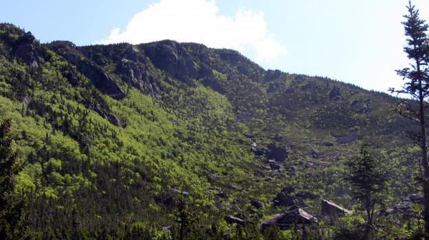
I snapped a quick photo of the bowl as I got above treeline on Boot Spurr

I quickly realized there was no way in hell I was hiking ~5 miles completely exposed on the peaks.  I didn’t really want to give up and go back the way I’d come though, so I decided the brave the wind for about a mile while I headed up to connect with Boot Spurr Link trail, and descend into the Ravine.  I threw on my shell, gathered my wits, and made agonizingly slow progress against the wind, sometimes on all four or bracing against cairns.  The steep descent of Boot Spurr Link wasn’t too much fun–no one had broken trail and I was postholing the entire way down the Hermit Lake.

It was still early morning, but there were a bunch of skiers at Hojos, heading up to Hillmans and the bowl, so I decided to make a day of it, and enjoy the blue skies and warm weather (and lower wind speeds).  There was the usual assortment of spring skiers, including people duct taping their skis to their packs and almost falling down left gully.  I hiked around the bowl a bit and took my time before descending the Tucks trail.  I felt a little silly hanging out in the bowl with a big pack but no skis with me.

Hillmans Highway

Hillmans Highway from Hojos

Skiers heading up left gulley

Skiers heading up left gully, which had some soft bumps

The rapidly deteriorating bowl

The rapidly deteriorating bowl, and waterfall hole

Afterwards, I camped out at Barnes Field and prepped for some skiing Saturday, since my backpacking plans had been comprised.  Due to some miscommunication between Alex and I, we didn’t meet up Saturday like we’d planned, and so Saturday morning I hung around Pinkham Notch until it looked like things were going to soften up, then made my way up to Hermit Lake on my own.  I made record time to Hojos, about 40 minutes I think, and chatted with a few people on the way up, including a guy who was planning to summit via Lion’s Head, since they just re-opened the summer route.

At Hermit Lake I talked with a ranger who speculated that the bowl still wouldn’t soften up   to prime corn for another hour or so, so I took my time and snapped a few photos for a group who were from the Johnson State College Outing Club.  When they found out I was on my own, they offered to let me join them.  They seemed like they knew what they were doing, so we departed together to ski Left Gully.  It turned out I’d been hiking up the Tucks trail with their friend earlier, and a few of them had been into back-country skiing and coming up to Tucks for a number of years.  It worked out great, they were super chill and it certainly made the day more fun than skiing on my own, and also gave me some peace of mind.

Though it was supposed to be cool and cloudy, the sun broke through, and I was sweating bullets in the heat as we ascended.  We hit Left Gully just as it got soft, and had a great first run.  I was feeling a bit slow on the ascent, I guess my jaunt Friday left me a bit tired.  For second run, we headed up Left Gully again just as some hiker narrowly avoid taking out the whole line after he lost his footing and slid down the entire run.  We topped out and headed towards Hillmans Highway across the rock fields, looking for a bit of variety.  I hadn’t skied Hillmans all season, so I was game to give it a try.  There was a choke point on the descent where you had to side-step down and the snow pack briefly got narrower than my skis, but the rest of the run was good spring conditions, though I doubt it will be worth skiing much longer.  The Sherburne was in rough shape.  You could kind of ski 30% of the way, as long as you didn’t mind skiing over rocks and grass and doing a bit of hiking in between.

On top of Left Gully

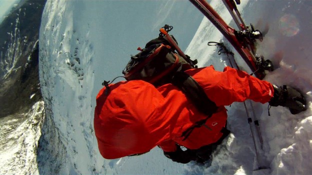
In the sun on top of Left Gully, you can see my skin beginning to take on a reddish hue.

The weekend ended up much different than I’d planned, mostly due to the rapidly changing weather.  Mt Washington is getting a bit of rain today, so it probably wouldn’t have been as much fun to ski anyway.  Thanks again to the friends I met at from outing club, especially Jess and Sam, it was a blast skiing with you guys!


One Water, One Coffee, One Beer…

…Such was our demeanor when we lumbered into Cafe Noche in Conway Village and hastily ordered all of the food and drink appropriate to the circumstances.  We had just skulked down from a day of superlative skiing in Tuckerman Ravine and were on the ride home this past Sunday .  Let’s rewind back to last Friday night for a full trip report…

Over the course of last week, Mount Washington somehow managed to pick up enough snow to fill in most of the lines in Tucks to a reasonable state.  Most of it was due not to actual heavy snowfall but to wind loading.  Our hope was that during the course of the week things would sinter enough that much of it would be skiable for the weekend.  We rallied in North Conway and prayed for a favorable weekend update and avy forecast.

As we got closer to the Notch, we were dismayed to see that snow was falling a good deal more heavily than had been forecast – great for the Wildcat crowd, not so great for us.  Between new snow and windloading we could be in for some sketchy conditions.  We arrived at Pinkham to find a fairly startling mix of Moderate and Considerable ratings.

We decided we’d skin up the Tucks Trail, change into crampons at the Lion’s Head Winter Route, climb to the ridge, and have a look at the east snow fields from which point we could easily summit and lap the East Snow Fields.  With so little protection from the wind and such mellow terrain, they should be pretty scoured and free from touchy slabs.

We arrived at the Winter Route to find a log jam of climbers messing around with their gear.  We were promptly advised by one of them, that shortly down the trail we would encounter an hour long wait while dozens of novice climbers were coached up and over the steeps.  None of us relished the idea of standing around in the wind in sub-zero temperatures, and we were forced to abandon Plan A.

We quickly settled upon a contingency plan:  we’d try our hand in The Lobster Claw, with the thought that it might be just filled in enough to be skiable, but still small enough to preclude the presence of any truly large slabs.  We continued to HoJo’s, de-skinned, got dressed for the cold, and prepared for some boot-packing.

Rob looks dubious as we head up into the bowl.

Alex breaks trail as we begin to wallow into drifts…

We realize it’s time to stop and evaluate the situation.

Some deep and crumbly looking snow pack.

Once we got into the bowl, it became totally socked in and gusty.  We started toward the snow fields under The Lobster Claw, bushwhacking through the un-buried shrubs and into ever deeper drifts.  Eventually, we realized that we needed to seriously consider the safety of the situation.  We started digging some snowpits and discovered small chunks of slab breaking off before we’d even finished digging out columns.  Kinda shady…  The poor visibility and double-digit sub-zero  temperature didn’t help much.  We decided to go no higher than the snow fields at the bottom of the Lobster Claw and stay out of the slide paths.  We’d get a few good turns in, and then pick our way to the Cutler River for maybe a few more untracked turns before the Sherbie.  In short: skunked.

We tried to make the best of it…

Ziehl in front and Alex in the background getting ready for action.

One of about a dozen decent turns….

Gettin’ tossed back…

Alex celebrates our prodigious accomplishment of skiing about 6 turns.

Well we tried to make the best of it anyway.   It was better than not skiing…  After picking our way through all the shrubs and junk in the floor of the ravine we began searching for the Cutler River in what was probably slowest wilderness travel I’ve ever participated in in my life: a knee to thigh deep wallow through frozen bushes and back and forth across the only partially frozen Cutler…

Yea. Adventure…

We finally make it to the skiable part of the drainage and get ready to make about 4 more turns…

Ziehl gets in a few good turns before the bottom of a pitch.


And then there was profanity…

Back at HoJo’s we conclude that we’d made the right choice…

And right on cue, as soon as we get back to the car, the skies clear and it turns into a beautiful day…

Well that was a debacle.  We called it quits for the day, planned out some rest and refueling, and contemplated our next move.  After some thought, we decided we’d get an early, start head up to HoJo’s and see what the report called for.  We were none too enthused about the inbound skiing story in New England, and thought a bad day in Tucks would probably be better than the same day in the resort.  We were pleasantly surprised, to say the least.  We arrived at HoJo’s to find that Left Gully and Lobster Claw were both de-escalated to a rating of Low.  Our path was laid clear before us: we quickly agreed to ski The LG and then make our way across the bowl to The Lobster Claw.  The LG if nothing else would be long, steep, and fast.  The Lobster Claw, we knew from the previous day, would have a decent amount of snow at least toward the bottom.  It was a good 20 degrees warmer, less windy and visibility was great – in hindsight I could have used my black lenses.  We eagerly went after The LG.

Rob leads the charge up LG.
The bowl from about half way up LG. Temping, but maybe not such a great idea.
At the top of LG, setting up a bench to get into our skis.
Check out that boot-pack.
Skier ready!

Rob charges some really firm, wind scoured snow.

Toward the runout, Rob steered us toward this sweet stash.
Ziehl slashes some powder turns toward the bottom of LG.

After warming on Left Gully, we decided to traverse across the floor of the ravine to scope the conditions on the south facing aspects.  In the clear skies, we could see that the coverage in Lobster Claw was a lot worse than we’d expected.  We decided to poke around under Right Gully to see how the conditions would be.  A number of people had already hiked all over lower portions of the south facing aspects.  The snow felt a good deal more stable than it had the previous day, and the southern aspects had been in the sun for a while by the time we got there, but we were still concerned about the pillowy convexities toward the top or the Sluice and Right Gully, so we stuck to the low angle bottom parts.  This was easily the best skiing of the weekend.  Ziehl took a turn behind the camera for a few runs.

The view on the way out. Has to be one of the bluest days on record for this place.

After a short dry spell of epic skiing, we finally hit some good luck and scored some high quality turns.  It seemed like we might finally be through the worst part of the winter (the part with no good skiing) and with lifted spirits we headed back down into The Valley in search of sustenance.Gear List (click links for more product info):

Black Diamond Factor 130 Alpine Touring Boot - Men's Black/Envy Green, 27.0Dynafit Titan TF-X Ski Boot - Men's White/Red, 27.5Dynafit TLT Vertical FT Z12 BindingBlack Diamond Fritschi Diamir Freeride Pro Binding -120MMBlack Diamond Contour Elliptic Trekking Poles - 1 Pair One Color, One SizeBlack Diamond Raven Pro Ice AxeBlack Diamond Raven Ice AxeBlack Diamond Sabretooth Clip CramponsThe North Face Patrol 34 Winter Backpack - 2135cu in TNF Black, M/LBlack Diamond Deploy 3 ShovelBlack Diamond QuickDraw Tour Probe 190Backcountry Access Tracker DTS BeaconBackcountry Access Tracker 2 Avalanche BeaconBlack Diamond Guide Glove - Men's Natural, MPetzl Cordex Belay/Rappel Glove Tan, MPOC Synapsis 2.0 Helmet White, MPOC Lobes Goggle Black/White, One SizePatagonia Capilene 1 Graphic Crew - Men's Mango, LBlack Diamond Ascension Nylon STS Skins One Color, 95mmSea To Summit Ultra-Sil Dry Sack XL/20 Liter, One SizeMountain Hardwear Compressor Insulated Hooded Jacket - Men's Blue Chip Sapphire, MMountain Hardwear Compressor Pant - Men'sMountain Hardwear Mountain Tech Vest - Men's Sapphire Black, MREI Shuksan Pants with eVent Fabric - Men's 32REI Gear ShopBuy GoPro HERO Camera at GoPro.comFree Shipping on Orders over $50