View Norway Basin in a larger map
The plan was to rally in Portland and embark on a shred-quest, the scale of which had been witnessed by none of us before… The team consisted of myself, Rob, his brother Brad, Brad’s best friend Ryan, and fellow ski team alum Karl. We’d rally in Portland, drive 6.5 east to Halfway, OR. From there we’d meet up with the Wallowa Alpine Hut guides at the Carson House and spend one last night in civilization before plunging into the wilderness. The following morning, the guides would tow us into the woods behind a snowmobile for roughly 6 miles, at which time, we’d skin an additional 2.5 miles and 2000 vertical feet to the Norway Basin yurt. The yurt would serve as our back-country skiing base-camp for the next 5 nights.

Halfway, OR…

Halfway to nowhere, in the words of Karl Cyr…

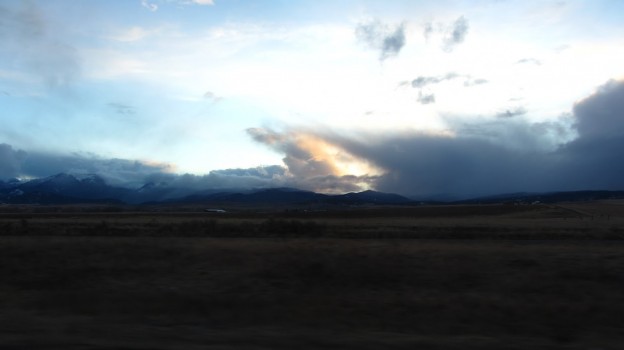
Plains, mountains…

…and sunsets.
View Norway Basin in a larger map
In the map above, the black path represents the drive, the green represents the snowmobile drag, and the blue is the skin to the yurt. The bed marks the Carson House.
View Norway Basin in a larger map

Right around now, it dawns on us: we’re actually doing this!
After some last minute ‘gear harmonizing’ at the trail head, we were on the trail, in pursuit of pow, gnar, first tracks, fist descents and virtually every other Holy Grail conceivable to five back-country skiers such as ourselves.
The snowmobile drag got off to a great start, including one overheated drive-train, resolved by shoveling a bunch of snow onto the tread, and one mid-course un-packaging of the gear sled, resulting in the loss of some miscellaneous gear, and all four tow-ees. The snow machine turned around and came back for us and the gear as soon as they realized that about 1000 lbs. of dudes had dropped off the tow line.
At about mile 6, we transitioned into climbing skins and prepared for the final push toward base camp. Laden with extra clothes, emergency gear, spare parts and overnight gear, the last 2.5 miles from the sno-mo drop-off to the yurt, took us nearly two hours. Once at the yurt, we took some time to unpack our non-essentials, hydrate and rest before a quick orientation with our guides, Kip and Victor. From a local high point, known as Rocky Top, they pointed out most of the significant land marks and major regions accessible from the yurt. Victor’s knowledge of the area proved indispensable and we left him hefty tip. Once we were all oriented, we took a quick schuss down to Bob’s Hole, the landing area for virtually everything west of the yurt, and then headed back to the yurt for some planning and R&R.

Home sweet, yurt.

Unloading any excess gear.
Photo credit: Ryan

So much gear!
Photo credit: Brad

Skin track.
Photo credit: Brad.

Photo credit: Brad.

Victor and Kip showing us the lay of the land.
Photo credit: Brad.


Transitioning.
Photo credit: Ryan.

Finally, a few glimpses into the terrain we’ll be skiing. The topo maps
don’t do it justice.


Photo credit: Brad

Inspecting our handiwork.
View Norway Basin in a larger map

Karl and Brad, doing some homework.
With about 3000′ of vert and one decent run under our belts we retreated to the yurt to gear up for the next day. The recent rain event and associated warm-up had destroyed virtually all of the deep persistent instabilities. There were a few sun crusts near the surface of the snow pack, but precipitation since the development of those layers had been sparse. If anything were to rip out, it would be low consequence. Additionally, the forecast for the following day was fair, but weather was expected to be moving in toward the end of the day. If we really wanted to get into the alpine and slay some big lines, we’d have one shot at it. We ate, drank, stared at the map until it was nearly committed to memory, and hit the sack for an alpine start the next day, with alarms set for 6 AM.

A lot to take in…
Continue Reading at The Oregon Trip: Big Mountain Lines.
Gear List (click links for more product info):